
Identify the following with the help of map reading.
(i) The island groups of India lying in the Arabian Sea and the Bay of
Bengal.
(ii) The countries constituting Indian Subcontinent.
(iv) The states through which the Tropic of Cancer passes.
(iv) The northernmost latitude in degrees.
(v) The southernmost latitude of the Indian mainland in degrees.
(vi) The eastern and the western most longitudes in degrees.
(vii) The place situated on the three seas.
(viii)The strait separating Sri Lanka and India.
(ix) The Union Territories of India.
Answer
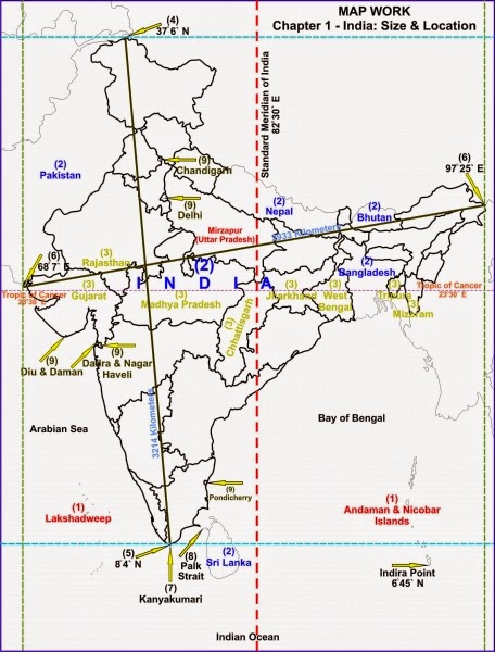
(i) Lakshadweep
(ii) Countries which make the Indian subcontinent are Pakistan in the
north-west, India at the core, Nepal in the north, Bhutan in the north-east and
Bangladesh in the east.
(iii) Tropic of Cancer passes through the states of Gujarat, Rajasthan, Madhya
Pradesh, Chhattisgarh, Jharkhand, West Bengal, Tripura and Mizoram.
(iv) 37°6' N
(v) 8°4' N
(vi) Western - 68°7' E, Eastern - 97°25' E
(vii) Kanyakumari
(viii) The Palk Strait.
(ix) Andaman and Nicobar Islands, Chandigarh, Dadra and Nagar Haveli, Daman and
Diu, Delhi, Lakshadweep, Puducherry (Pondicherry).