Houses in Rajasthan have thick walls and flat roofs. The thick walls do not allow the heat to get into the houses while the flat roofs help to retain the little water that comes as rain in the desert.
By: Admin
The houses in Tarai region, Goa and Mangalore have sloping roofs so that the rainwater due to heavy rains in these area flow off the roof.
By: Admin
The houses are built on stilts in Assam as there is danger of floods and wild animals in large areas of Assam.
By: Admin
Most of the world’s deserts are located in the western margins of continents in the subtropics because trade winds that blow in the region shed their moisture on the eastern side.They become dry by the time they reach the western margin of the continent. Cold ocean currents also tend to stabilise the air over the coast and inhibit cloud formation.
By: Admin
Which of the following places receives the highest rainfall ?
(a) Guwahati
(b) Mawsynram
(c) Kolkata
(d) None of these
ANS (b) Mawsynram
By: Admin
The wind blowing in the northern plains in summers is known as:
(a) Kaalbaisakhi
(b) Loo
(c) Trade winds
(d) None of the above
ANS (b) Loo
By: Admin
Which one of the following causes rainfall during winters in northwestern part of India?
(a) Cyclonic depression
(b) Retreating monsoon
(c) Western disturbances
(d) Southwest monsoon
ANS (a) Cyclonic depression
By: Admin
Monsoon arrives in India approximately in:
(a) Early May
(b) Early July
(c) Early June
(d) Early August
ANS (c) Early June
By: Admin
Which one of the following characterises the cold weather in India?
(a) Warm days and warm nights
(b) Warm days and cold nights
(c) Cool days and cold nights
(d) Cold days and warm nights
ANS (b) Warm days and cold nights
By: Admin
The elements affecting the climate are Latitude, Altitude and Pressure & Winds, distance from the sea (continentality), ocean currents and relief features.
By: Admin
India have a monsoon type of climate because the climate of India is governed by the monsoon winds which are limited between 20° North and 20° South.
By: Admin
The Indian desert located in the north-western part of India experience the highest diurnal range of temperature because of the sand present there quickly becomes hot during day and cools down rapidly during night.
By: Admin
Malabar Coast gets rains from South-West Monsoon Winds.
By: Admin
Jet streams are high velocity westerly winds blowing through a narrow zone in the upper troposphere. The westerly flows are responsible for the western disturbances experienced in the north and north-western parts of the country. The easterly jet streams cause tropical depressions during the monsoon as well as October-November months.
By: Admin
Monsoon refers to the seasonal reversal in the wind direction. Monsoon ‘break’ refers to the happening of wet and dry spells during the rainy season. The monsoon rains take place only for a few days at a time.
By: Admin
The monsoon is considered a unifying bond because:
→ The Indian landscape, its flora and fauna, etc. are highly influenced by the monsoon.
→ These monsoon winds bind the whole country by providing water for agricultural activities
→ Most of the festivals in India that are related to agricultural cycle may be known by different names in different parts of the country, but their celebration is decided by the monsoon.
→ Year after year, people of India from north to south and from east to west, eagerly await the arrival of the monsoon.
→ The river valleys which carry this water also unite as a single river valley unit.
By: Admin
The Bay of Bengal branch of south-west monsoon moves towards northeast carrying more moisture and they give heavy rainfall in this region. As they move further towards west, they carry less moisture content with themselves resulting in decrease in rainfall in the west
By: Admin
Seasonal reversal of wind direction over the Indian subcontinent takes place due to pressure differential. El Nino has major role to play in the seasonal reversal of wind direction over the Indian subcontinent.
By: Admin
The monsoon begins from the first week of June and advances quite rapidly to cover almost the whole country by mid-July. Hence, the bulk of rainfall in India concentrated over the months of a few months; mainly June to August.
By: Admin
The Tami Nadu coast receives winter rainfall because of movement of low-pressure conditions to the Bay of Bengal.
By: Admin
The Bay of Bengal is the centre of various pressure changes and hence there is always a chance of development of cyclone. Due to this, the delta region of the eastern coast is frequently struck by cyclones.
By: Admin
The parts fall in the rain shadow area of the Aravalli. Hence, they are drought prone as they don't receive much of rainfall.
By: Admin
There is regional variation in the climatic conditions of India. Temperature and Precipitation vary from place to place and season to season.
→ In summers the temperature rises up to 50°C in parts of Rajasthan, whereas it may be around 20°C in Pahalgam in Kashmir.
→ In winters night temperature in Drass in Kashmir may be minus 45°C, whereas in Tiruvanantapuram in Kerala may have a temperature of 20°C.
→ In Andaman Islands the difference between day and night temperature may be hardly 7° - 8°C.
→ Coastal areas experience less contrast in the temperature, whereas seasonal contrasts are more in the interior of the country.
→ There is decrease in rainfall generally from east to west in the northern plains.
→ Most part of India recieve rainfall from June – September, whereas some parts like the Tamil Nadu coast gets a large portion of its rain during October and November.
By: Admin
Following are the factors responsible for the mechanism of monsoon:
→ The differential heating and cooling of land and water creates low pressure on the landmass of India while the seas around experience comparatively high pressure.
→The Inter Tropical Convergence Zone (ITCZ) is normally positioned about 5°N of the equator. It shifts over the Ganga plains during summer. It is also known as the monsoon trough during the monsoon season.
→ The high pressure area, east of Madagascar is approximately 20°S over the Indian Ocean. This area affects the Indian Monsoon.
→ The Tibetan plateau gets intensely heated during summer. This results in strong vertical air currents and formation of high pressure over the plateau. This high pressure zone is about 9 km above the sea level.
→ The westerly jet stream move to the north of the Himalayas, and the tropical easterly jet stream moves over the Indian Peninsula during summer.
→ The periodic change in pressure conditions between Pacific Ocean and the Indian Ocean that is known as the Southern Oscillation or SO also affects the monsoon.
→ The difference in pressure over Tahiti and Darwin is computed to predict the intensity of the monsoons. Tahiti (18°S/149°W) lies in the Pacific Ocean and Darwin (12°30'S/131°E) lies in northern Australia. If the pressure differences are negative, it means a below average and late monsoon.
By: Admin
Following are the features of the cold season:
→ The winter season begins from mid-November and till February; in northern India.
→ December and January are the coldest months in the northern part of India.
→ The temperature ranges between 10°-15°C in the northern plains, while it ranges between 24°-25°C in Chennai.
→ Days are warm and nights are cold.
→ Frost is common in the north and the higher slopes of the Himalayas experience snowfall.
→ The northeast trade winds prevail over the country in this season. As these winds blow from land to sea, most parts of the country experience a dry season.
→ The weather is usually marked by clear sky, low temperatures and low humidity and weak variable winds.
→ The inflow of the cyclonic disturbances from the west and the northwest is a characteristic feature of the cold weather over the northern plains.
→ These low-pressure systems originate over the Mediterranean Sea and Western Asia and move into India. They cause winter rains over the plains and snowfall in the mountains.
→ The winter rainfall is in small amount but is very important for the rabi crop. This rainfall is locally known as mahawat.
→ The peninsular region does not have a well- defined cold season due to the moderating influence of the sea.
By: Admin
Characteristics of the monsoon rainfall in India:
→ The duration of the monsoon varies from 100 to 120 days from early June to mid- September.
→ Around the time of its arrival, the normal rainfall increase suddenly and continues regularly for several days. This is called the 'burst' of the monsoon.
→ They are distinguished from the pre-monsoon showers because of their increase in rainfall amount and regularity.
→ The monsoon arrives at the southern tip of the Indian Peninsular generally by the first week of June.
→ The rainfall is unevenly distributed across the country.
Effects of the monsoon rainfall in India:
→ Agriculture in India largely depends on Indian monsoons for water. Late, Low or excessive rains have a negative impact on crops.
→ Due to uneven distribution of rainfall across the country, there are few places that are drought prone and few are flood affected.
→ The monsoon provides India with a diverse climatic pattern. Hence, in spite of the presence of great regional variations, it has a unifying influence upon the country and its people.
By: Admin
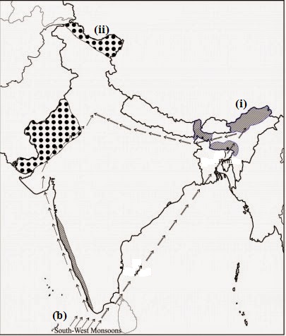
On an outline map of India, show the following.
(i) Areas receiving rainfall over 400 cm.
(ii) Areas receiving less than 20 cm of rainfall.
(iii) The direction of the south-west monsoon over India.
Answer
By: Admin
1. Besides landforms and drainage, which is the third basic element of the natural environment?
(a) Temperature
(b) Wind
(c) Rainfall
(d) Climate
2. Why do we wear woollen clothes in winter?
(a) To ward off cold
(b) To ward off heat
(c) To remain calm
(d) To remain drenched
3. The sum total of weather conditions and variations over a large area for a long period of time is called
(a) weather
(b) climate
(c) hot weather
(d) cold weather
4. The state of atmosphere over an area at any point of time is known as
(a) weather
(b) climate
(c) heat
(d) cold
5. Why do coastal areas experience less contrast in temperature conditions?
(a) Due to moderating effect of the seas
(b) Due to land mass
(c) Due to heat conditions
(d) Due to none of the above three
6. Which of the following climatic controls is the most important?
(a) Latitude
(b) Altitude
(c) Pressure and wind system
(d) Continentality
7. An apparent force caused by the earth's rotation is called
(a) coriolis force
(b) centrifugal force
(c) centripetal force
(d) jet stream
8. A broad trough of low pressure in equatorial latitudes is known as
(a) coriolis force
(b) ITCZ
(c) jet stream
(d) centripetal force
9. The state of normal rainfall increasing suddenly and continuing constantly for several days is named as
(a) break
(b) burst
(c) mango shower
(d) kaal baishakhi
10. What is a mango shower?
(а) Premonsoon rainfall in Karnataka and Kerala
(b) Rainfall in June to September
(c) Rainfall in winter days
(d) Rainfall caused by western disturbances
Answers :
1. (d) 2. (a) 3. (b) 4. (a) 5. (a)
6. (a) 7. (a) 8. (b) 9. (b) 10. (a)
By: Admin
Mawsynram
By: Admin
Hot days and cool night
By: Admin
Mango Showers come in winters
By: Admin
The Deccan Plateau
By: Admin
1. Loo is the striking feature of hot weather season.
2. These are strong gusty, hot dry winds blowing during the day over the north and north western India.
3. These are very hot winds so the direct exposure to these winds is very harmful.
By: Admin
1. Towards the close of summer season, pre monsoon showers are common, especially in Kerala and Karnataka.
2. This spell of rainfall pours down at the end of the summer in hot weather season.
3. They help in early ripening of mangoes.
4. These are called as ‘mango showers’
By: Admin
1. Mawsynram is located at 25018’ N and 91035’ E in the state of Meghalaya.
2. It is 16 km west of Chiraapunji. It gets the heaviest rainfall in the world.
3. The warm moist air coming from the Bay of Bengal during the monsoon is forced to rain here due to the Khasi hills.
4. The Khasi hills forced the rain bearing winds to rainfall here.
By: Admin
1. The months of October and November are dry months.
2. Sky become clear and due the dryness temperature begins to rise.
3. The days become very hot in October.
4. This period of high day-temperature is called the October Heat.
By: Admin
1. The areas receiving an annual rainfall of more than 200 cm come under the areas of very heavy rainfall.
2. The Western Ghats, North-eastern parts of India are the areas getting rainfall more than 200 cm per annum.
3. Some areas such as Mawsynram and Cheraapunji get rainfall more than 1000 cm per annum
By: Admin
1. The areas of heavy rainfall get 100-200 cm rainfall annually. Eastern slopes of Western Ghats, northern parts of India, Orissa, and Madhya Pradesh etc get 100200 cm rainfall.
2. The area of low rainfall gets 60-100 cm rainfall. Maharashtra, western Madhya Pradesh, parts of Gujarat, Andhra Pradesh, Karnataka, eastern Rajasthan etc are the areas getting 50-100 cm rainfall annually.
3. The areas of very low rainfall getting less than 60 cm rainfall are termed as the very low rainfall areas. Desert areas of Rajasthan and Gujarat, Ladakh region of Jammu and Kashmir and Leeward side of the Western Ghats get less than 60 cm rainfall
By: Admin
1. The Western Cyclonic Disturbances are weather phenomena of the winter months.
2. They are brought in by the westerly flow from the Mediterranean region.
3. They usually influence the weather of the north and north western regions of India.
4. They bring rainfall in the states of Punjab, Haryana and western Uttar Pradesh.
5. Tropical cyclones occur during the monsoon as well as in October-November, and are part of the easterly flow.
6 This rainfall is very beneficial for the Rabi crops.
By: Admin
1. The monsoon arrives at the southern tip of the Indian peninsula generally by the first week of June.
2. Subsequently, it proceeds into two branches, Arabian Sea Branch and the Bay of Bengal branch.
3. The Arabian Sea branch reaches Mumbai about ten days later on approximately the 10th of June. The Bay of Bengal Branch also arrives in Assam in the first week of June.
4. By mid June the Arabian Sea branch of the monsoon arrives over Saurashtra, kuchchh and the central part of the country.
5. The Arabian Sea and the Bay of Bengal branches of the monsoon merge over the north western part of the Ganga plains.
6. By the first week of July, western Uttar Pradesh, Punjab, Haryana and Eastern Rajasthan experience the monsoon.
By: Admin
It is the total of weather conditions and variations of an area for a long period of time. It includes study of temperature, rainfall, atmospheric pressure etc.
By: Admin
Weather refers to day to day changes in our atmospheric conditions. It also includes temperature, rainfall and atmospheric pressure.
By: Admin
Inter Tropic Convergence Zone
By: Admin
1. The areas or the side of a mountain which gets more rain is called the windward side.
2. It receives more rain because it is front side of the mountain.
3. Mumbai is on the windward side. so gets heavy rainfall.
By: Admin
1. The sloped side of a mountain which is dry and gets less rain is called the leeward side.
2. It is dryer because when the clouds climb the mountains, they lose most of its water, so this part remains dry.
3. Pune is on the leeward side, so gets the less rainfall.
By: Admin
1. The Himalayas intercept the south west monsoon and cause rainfall in the northern India.
2. They prevent the cold wind of central Asia from entering into India.
3. The Himalayas check the monsoon wind and do not allow them to cross otherwise the North India would be a desert.
By: Admin
1. Monsoon advances in the month of June and covers the country in about a month.
2. The low pressure condition intensifies over the northern plains by the beginning of June.
3. It attracts the trade winds of the southern hemisphere.
4. These south east trade winds originate over the warm subtropical areas of the southern oceans flowing towards south westerly direction, crossing the equator and entering in the Indian peninsula like the south west monsoon.
By: Admin
1. The monsoon trough or the low pressure trough becomes weaker over the northern plains with the apparent movement of the sun towards the south during October-November.
2. This is replaced slowly by a high pressure system. The south-west monsoon winds begin withdrawing slowly and steady.
C. The monsoon withdraws from the northern plains in the beginning of October. The October-November months from a transition period from hot rainy season to dry winter season.
By: Admin
1. Mumbai receive more rainfall in rainy season from Arabian Sea branch from JuneSeptember.
2. Mumbai is located on the western coast which comes in the way Arabian Sea branch at its earliest.
3. It is located on the windward side of the Western Ghats which receives very heavy rainfall, more than 250 cm.
By: Admin
1. The cold weather season remains from mid November to February in northern India. December and January are known as t he coldest months in the northern parts of India.
2. The temperature decreases form south to the North. In the eastern coast, the Average Temperature of Chennai is between 240 -250C, while in the northern plains it ranges between 100 -150 C.
3. There is warmness in the day and coldness in the night.
4. There is snow fall on the higher slopes of the Himalayas and frost is common in the north.
5. The northeast trade winds flow over the country during this season. They blow from land to sea.
By: Admin
1. There is hot weather season from March to May in India.
2. The temperature recording taken during march- May at different latitudes clearly shows the influence of the shifting of the heat belt.
3. The Highest temperature is about 300 C in Gujarat and Madhya Pradesh in April. In May, the temperature commonly reaches at 450 C in the north western parts of the country.
4. Due to the moderating influence of the oceans, the temperature remains lower in peninsular India. E. The Temperature rises and air pressure falls in the northern part of the country during summer month.
5. At the end of May, an elongated low pressure area develops in the region extending from the Thar Desert in the north-west to Patna and Chota Nagpur plateau in the east and south-east.
6. ‘Loo’ is the most striking feature of the hot weather season.
Need more help?
To start up with Doubt classes and coaching with EDUINFY Tutors Feel free to contact us.